Copper was discovered there in 1843.
This discovery would impact the lives of Copper Basin residents for generations. Population growth, land
speculation, numerous mine openings and other related activities led to the boom of the area by the early
1850’s. However, no one knew that the state-of-the-art technology being used at that time to
process copper would have devastating effects on the
environment. In fact, the devastation was so great the
Copper Basin was once considered the largest man-made
biological desert in the nation. Over 50 square miles
(32,000 acres) was stripped of vegetation resulting in mounds
of soil being washed away with each rainfall. Sulfuric
acid fumes filled the bowl-like topography and led to the
nation’s first look at the long-term effects of acid
rain.
The Ducktown Basin, or Copper Basin,
is located in the extreme southeast corner of Polk County,
Tennessee. Three veins of copper run through the basin
and each attracted several mining companies ready to
exploit the resource.
The early inhabitants of the Basin
were Cherokee Indian farmers who were hunters and produced
some copper. By the Treaty of New Echota in 1836 they
gave up many of their lands, including those in the Copper
Basin. Many of the Indians who remained in the Basin
after the treaty were removed by the U.S. Army in 1838 during
the Trail of Tears.
Because there were no roads into the
Basin, settlement was slow to occur. The first white
settlers came to the area to farm, but until 1839 there
was little white settlement. That year, prices
were lowered from the starting price of $7.50 an acre, which
had been established when the land was surveyed after the
Indian Removal, to only $l an acre. The farming community of
Pleasant Hill was founded around 1840 east of present-day Copperhill, the first organized settlement in the Basin.
The lack of roads into the Basin
increased its isolation and prevented economical shipment of goods outside the Basin and helped retain an agricultural
lifestyle. The earliest recorded shipment of copper out of the
Basin occurred in 1847 when shipped, by mule, 90 casks of
copper to Dalton, Georgia, the nearest railroad. It was shipped north of
the Revere Smelting Works near Boston.
In 1851, the Copper Road between
Hiwassee and Cleveland began to be constructed in Bradley County and was completed in 1853. Now copper could be
taken economically by copper haulers to Cleveland for shipment, and other goods could be brought back
into the Basin. Copper haulers would make this journey in two days, spending the night at a
halfway house. On the return trip from Cleveland the
wagons were usually loaded with merchandise for the stores,
and with mining supplies. The original road was used
throughout the 1800s as the only way to ship copper out of
the Basin. (The road route was later used for part of
U.S. Hwy. 64.)
In 1857 only five mines were
operating regularly -- the Tennessee, Mary’s, Isabella,
Eureka, and Hiwassee. In 1858 the mines in the Basin
began to consolidate into three large companies -- the Union
Consolidated Mining Company, the Burra Burra Copper Company,
and the Ducktown Copper Company.
The Civil War disrupted work at the
mines, as the miners left to fight in the war and the mines closed down. Many mine interests and smelting plants
were owned by northern industrialists who closed the mines in late 1861. The confederacy gained
control of the Basin in 1863 and sold the mines to southern
capitalists to provide the south with needed copper.
The mines were operated at a reduced capacity through the end
of 1863 when Federal troops again gained control of the
area. After the Civil War the miners and their families
returned, the damage to the mines was repaired, and mines
reopened. The Burra Burra and Union Mines were reopened
in 1866, the first to do so.
The Copper Basin’s ore is three
deep seams and could only be extracted by deep shaft mining,
a dangerous activity. Dynamite charges used to loosen
ore could cause cave-ins and many miners lost their lives in
the mines.
In the late 1870s most of the mining
companies in the Basin began to fail because of a lack of
adequate transportation and decreasing quality of ore.
The cost of transporting the ore would have been greatly
reduced by rail. Without rail transportation it became
uneconomical to ship copper.
The copper mines in the Basin were
idle for more than ten years until the Marietta and North Georgia Railroad built a spur line north to the area.
The arrival of the railroad ended the isolation of the Basin and made transportation of people and products
easier.
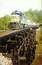
The Georgia spur was met soon
by the spur from upper Tennessee. The major obstacle in
the Tennessee line was the Hiwassee River gorge, with a 426-foot
difference in the height between the north and south shores of the river. George Eager of
the Knoxville Southern Railroad designed a switchback to eliminate the obstacle. The switchback
was located near Farner, Polk County, Tennessee. The completed rail resembled a “W”
built up the river gorge.
These two lines consolidated in 1890
as the Marietta & North Georgia Railroad. It passed
into receivership in 1891 and was reorganized in 1895 as the
Atlantic, Knoxville, and Northern Railroad Construction Company (AK&N). In 1896 it was finally
incorporated and began to run the rail line.
In 1890 the Ducktown Sulphur, Copper
and Iron Company (DSC&I) of London, England, re-opened the Mary mine and built a furnace with a l00-ton-a-day
smelting capacity.
In 189l the open roast heap smelting
process of copper was begun. This process, and the high
sulfur content in Polk County copper, created sulfuric acid
fumes which, combined with the timber cut as fuel, destroyed
vegetation in the Basin.
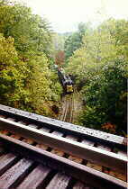
They replaced the cumbersome
switchback at the Hiwassee Gorge with a loop around Bald Mountain in the gorge. The loop was necessary because a
train could pull only three or four cars up the
switchback, and a pusher train was needed to help get the
trains up. This was very time consuming at a time when
the line was getting more traffic. T.A. Aber, a civil
engineer with the Louisville and Nashville Railroad, designed
a loop around Bald Mountain, in the middle of the Hiwassee
River, to eliminate the switchback. The loop, over
8,000 feet long, would circle the mountain one and a half
times up a passable grade until it reached the plateau height
near Farner north of Ducktown. Trains began running
over the loop in 1898 and continue to do so today.
By 1899 the Tennessee Copper Company
had bought or leased mines from most of the other mining
companies in the Basin. They built a new smelter in
McCays (renamed Copperhill) and built a railroad between
Ducktown and the smelter. They began a new mine, the
Burra Burra near the Hiwassee Mine site.
Two lawsuits involving the Basin
Copper industry occurred at this time in 1904 by landowners. Tennessee courts ruled that the value of the copper
companies’ contributions to the county out-weighed damages they caused. Before the copper industry
came to the area, there were only around 200 residents.
The court noted that, at that time, the open-roast heap
method of smelting was the only known smelting method.
In 1906 in Georgia vs.
Tennessee Copper Company, the Supreme Court heard
Georgia’s claim that TCC was taking away its sovereign rights of control over
its land and air. Georgia was seeking an injunction
preventing TCC from using the open roast heap method.
The Court found for Georgia but did not issue the injunction
because by then TCC had begun construction of an acid
reclamation plant near Copperhill. Eventually, sulfuric
acid replaced copper as the company’s major product.
Within two decades of the ruling the
first efforts would be made to reclaim the barren landscape. Those efforts would continue into the 1990’s.

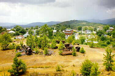
Once looking more like Mars
than East Tennessee. Over 50
Sq. miles were stripped
of vegetation
Another technological
advancement which occurred in the Basin was a way to extract
iron compounds from the copper ore. This allowed the companies to
retrieve iron, copper and sulfuric acid from the mines.
Reforestation efforts began in the
1920s and 1930s and concentrated efforts began in the 1940s.
Early efforts were carried out by the mining companies and
TVA. Hundreds of acres of pine were planted between
1939 and 1944.
In 1941 the TVA established a
CCC camp in the Basin to enhance their tree planting
efforts. The CCC workers built dams, planted trees, and
covered the ground with straw to prevent runoff. Six-
teen buildings existed in 1941; all that remains are ruins of
some foundations and leveled sites where the buildings stood.
Later owners of the copper mines and
acid production facilities were Cities Service and Tennessee
Chemical Company. Throughout the 1980s, the vast
company land holdings began to be sold off. In 1987,
the copper mines were closed and sulfur was brought in by
rail for acid production. Tennessee Chemical Company
filed for bankruptcy. The production facilities were
purchased by Boliden Intertrade AG, a Swiss company, and
renamed B.I.T. Manufacturing.
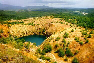
The Burra Burra Mine Pit today...Notice the
Reclamation
Efforts
Have proven to be Successful. The Goal is to Have
Complete
Reclamation by the Year 2000.