

Starr Mountain is located partly in the southwest corner of Monroe County Tennessee and in Polk County, in the Cherokee National Forest. The flat plateau like mountain is about halfway between
Tellico Plains and Etowah. It's elevation ranges from 750 to 2290 feet. Surrounded by valleys and bisected from Oswald Dome to the south by Hiwassee River,
the two mountains look like islands encircled
by a sea of green. Hikers, horses, and
mountain bikes are allowed on gated (closed)
roads unless otherwise posted.
US 411 runs along its west face and TN 315
(Reliance Road) along its east face.
GPS Coordinates Starr Mtn. Road &
Hwy. 39 (Mecca Pike Road):
N. 35 Degrees - 20.697'
W. 084 Degrees - 24.046'
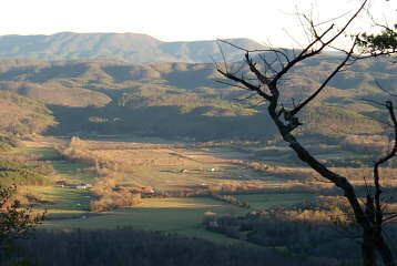
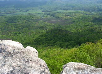
View of Rural Vale Community from White Cliffs.
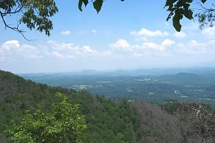
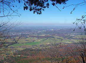
View From White Cliffs Looking Toward
Tellico Plains and the Tellico District.
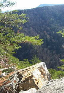
Cliffs on the Southern Edge of
Starr Mountain Overlooking the
Gee Creek Wilderness Basin.
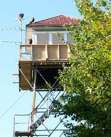
Buzzard's Roosting on the Abandoned
Fire
Tower on Starr Mountain

Bullet Creek Falls

Several Easy to Moderate Trails
are Located on Starr Mountain.
Hiking - Bicycling - Horse Trails
White Cliffs Overlooking the Rural Vale Valley.
![]() .
.
View West Looking Down on Etowah.
History Of Starr Mountain
Starr Mountain in the latter days of the Cherokee Nation, was the domain of one man, Caleb Starr, and therefore bears his name. Like many of the whites in the area, he had come across the mountains from North Carolina and married a Cherokee. His wife was prominent among the Cherokees, being the granddaughter of Nancy Ward. Caleb amassed great wealth; he owned Starr Mountain which is some 20 miles long and had a plantation at the base of it which was worked by over one hundred slaves.
He and his wife had twelve children, one of whom was James Starr, who was one of the factions of Cherokees who signed the infamous "Treaty of New Echota" in 1835. This resulted in the removal of the Cherokee nation including Caleb Starr and all of his children (except James) to Oklahoma on the "Trail of Tears". Once in Oklahoma the Starr’s were identified with the "Treaty Party" and many (including James) were murdered in the unrest that followed.
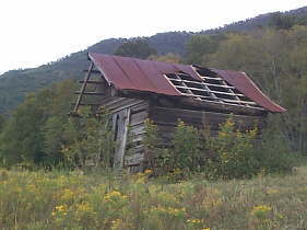
This Shed is the Only Remaining
Structure
of Caleb Starr's Plantation.
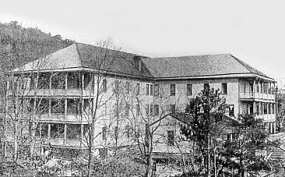
White Cliffs Hotel
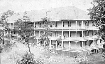
Old White Cliffs Hotel
Later Starr Mountain was home to a famous resort hotel, the White Cliff Springs Hotel, and also gained press attention as the home of the "Hermit of Starr Mountain", Mason Evans. The escapades of the hermit were picked up and reprinted in many newspapers. Mason Evans, rejected in love, fled to the mountain as a young man in his twenties and resided there in a cave until he died of exposure at age 68. His life is chronicled in a book entitled "Torment in the Knobs" by R. Frank McKinney, longtime editor and publisher of the Etowah Enterprise.
The famous Bandit Queen of the late 1800’s, Myra Maybelle Shirley, better known as Belle Starr, married Sam Starr, great grandson of Caleb in 1880, where she took on the name of Starr. The newlyweds cleared land and settled into a cabin at Younger's Bend, on the Canadian River about 70 miles southwest of Fort Smith, Ark.
Sam’s father Tom was a murderous Cherokee, so notorious that he was an embarrassment to the Cherokee. When James Starr was assassinated, son Tom swore vengeance and carried out his oath with 20-plus murders. He was later pardoned because of a unique quirk in a federal peace treaty.
At there home in Younger’s Bend they were visited by many outlaws seeking refuge. Belle did not encourage these activities. It was her hope, "to live out her time in peace." There is no evidence that Belle was the leader of any outlaw band, or that she ever visited Starr Mountain as some claim.
She did serve time for horse stealing and was charged with robbery in 1886 but was later acquitted. She was ambushed and killed by two shotgun blasts February 3, 1889 near Younger’s Bend.

Cave Entrance Where Mason Evans
Lived for 40 Years. GPS Coordinates
Trailhead Parking: N. 35 Degrees - 20.308'
W. 084 Degrees - 24.884'
Cave: N. 35 Degrees - 20.412'
W. 084 Degrees - 24.773' - Elev. 2029'
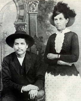
Murderer Bluford "Blue" Duck and
Belle Starr May 24th., 1886.
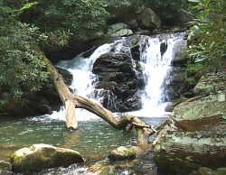
Gee Creek Waterfalls in the Gee Creek
Wilderness Area. Located at the Southern
End of Starr Mountain.

Old Cabin Near Yellow Creek.
